
Etosha National Park II, Namibia
It breaks my heart to say that this is my LAST post from my trip to Africa. It was truly the trip of a lifetime, both as an incredible family adventure as well as a photographers dream destination.
Days 13-15. As mentioned in my previous post, the tail end of our trip was in Etosha National Park. The last three days were spent in the Erindi Private Game Reserve with such creature comforts as a cool bed, air conditioning, and all you can eat buffets surrounded by clean smelling tourists. It really felt odd to be experiencing Africa in this manner, and we frequently longed to get back to the true bush. The morning and evening driving safaris were now with the private Erindi team (our FANTASTIC guides Sascha and Jimmy from Southern Cross Safaris had left us in Erindi and headed back home to prepare for their next trip). These tours now felt a little more like theme park rides in that many of the larger animals were radio tagged for easier tracking, and there was often a number of vehicles surrounding the larger animals. Overall, it was still a fantastic experience and we were treated to a huge and diverse variety of animals on every tour.
Finally, I want to thank Southern Cross Safaris for an epic experience. Sascha and Jimmy made us feel like family, and their wilderness knowledge and experience opened up a world to us that few get the opportunity to see. We can’t wait to return!
Click to enlarge images.


Drinking

Momma and Baby

Out for Dinner
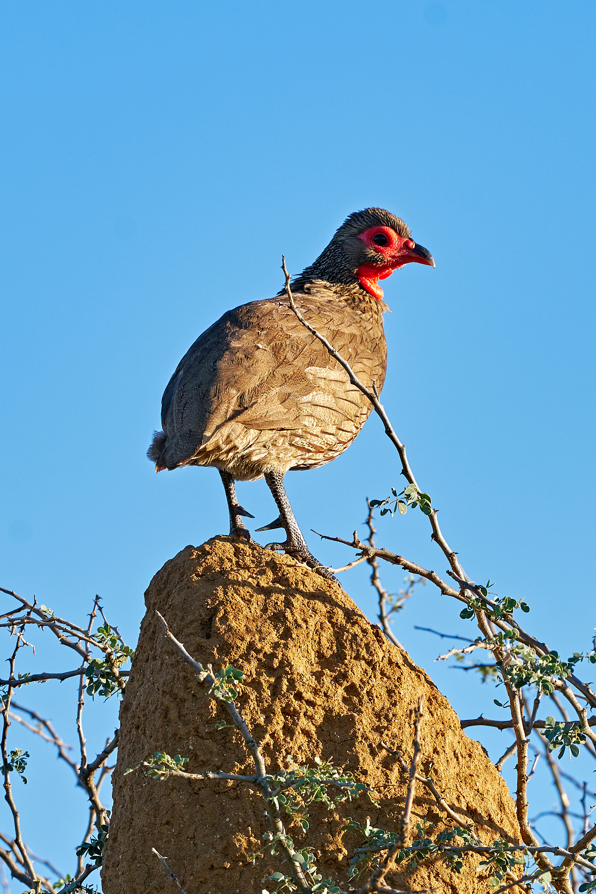
Swainson’s Spurfowl

Baby Elephant

Mongoose

Weaver Birds Nests

Momma and Baby Black Rhino


Black Rhino


Baboons

Sandgrouse


The Gang

Me and the Girls

Our Last Namibian Sunset

Goodbye Africa…
Etosha National Park, Namibia
Days 11-12. When planning our trip, we designed the last few days to be a little on the easier and more comfortable end of the safari spectrum. Rather then set up our own tents and cook our meals while isolated in the deep wild, we decided to stay in two different safari lodges (complete with hot showers and beds…and crowds of clean tourists and all you can eat buffets overlooking watering holes). It was a bit of a shock, and we felt awkward experiencing Africa in this more controlled and catered manner. The first two days were spent at the Halali Camp, and luckily our original guides stayed with us at this camp and also took us on the early morning and evening game drives in Etosha National Park. Click to enlarge images.


Black Nosed Impala

Earth’s shadow


Etosha Pan

Evening Springbok


Momma and baby Black Nosed Impala

Pale-Chanting Goshawk


Pale-Chanting Goshawks
Etosha Pan

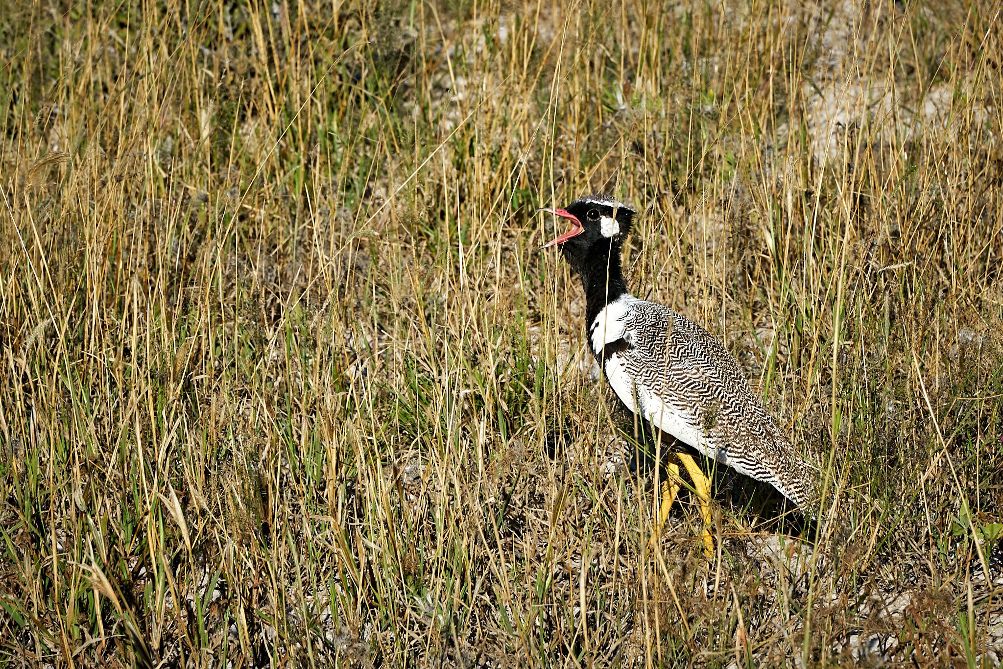
Southern Black Korhaan

Springbok

Grandma and the girls

Waterbuck

Etosha Pan Posse

Etosha Sunset
Crismon-Breasted Shrike
There was nothing in Namibia that impressed us more than the spectacularly beautiful mating season courtship rituals of the crimson-breasted shrike.

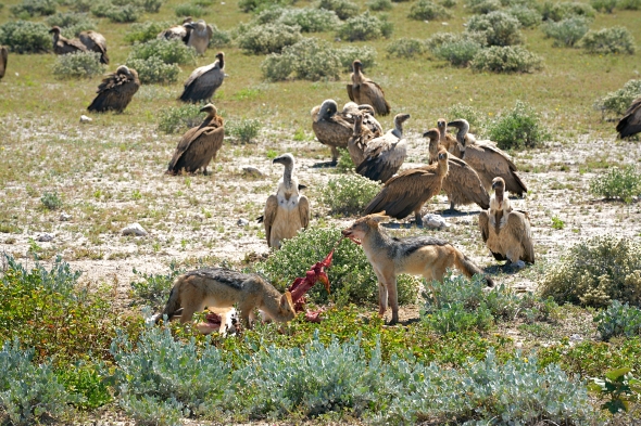
Jackals and Hide
Namibia Day 11 began with a morning game drive, our first at Etosha National Park. Soon into the drive we came across a fresh kill, a springbok that had been taken down recently by presumably a cheetah. By the time we arrived, the cheetah had eaten its fill and moved on, leaving the remains for the scavengers. What ensued appeared as somewhat of a survival “dance” between the jackals and the vultures as they repeatedly parried each other for a chance to feed.
Click on the image below to view a short video of the encounter. Caution: Gory! Also, please change quality to 1080p (auto is 720 ) and view full screen!
Damaraland to Etosha, Namibia
Day 10 brought a drive out of the wild and into “civilization”. We were headed to Etosha National Park (with showers and beds), a 22,270 sq km/8,600 sq mi park which gets its name from the Etosha Pan, a salt pan which covers a quarter of the total area of the park and is so large that it is identifiable from space. Our drive to the park took us through scattered Damara villages, where farmers who subsist on herding cattle, sheep, and goats still live primarily in simple homes constructed from dung and termite mud (collected from MASSIVE termite hills) spread on a wooden frame.


Massive termite hills were scattered throughout the countryside.

Himba Women out for a stroll


Springbok “pronking”
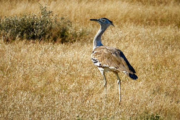 Kori Bustard

Milky Way over Damaraland, Namibia
Night 9 brought a goodnight and goodbye to the Damaraland (Palmweg) Concession in north-western Namibia, bringing to a close the most primitive wild camping portion of the tour. From here we head back to “civilization” in the form of Etosha National Park.
Click on photo to view an enlarged 10 panel shot of Milky Way taken from the edge of our campsite.

Exploring the Wilds of Damaraland, Namibia
Namibia Days 8 and 9 were spent exploring the massive Damaraland (Palmweg) Concession in north-western Namibia. Daily sunrise departures from our camp into the concession provided the best opportunity to enjoy the cool mornings and experience the wildlife as they completed their nighttime activities and began to settle in and take cover from the approaching scorching sun and high temperatures. Our afternoons were spent taking cover as well, mostly resting/reading and playing games in the shade at camp. Late afternoon and evenings consisted of additional drives to explore the surroundings and/or gin and tonic “sundowners” as the sun dipped beneath the African horizon.


Rhinoceros rubbing stone, which has been polished to a shine over the centuries by Rhinos scratching themselves.


Black-backed jackal

Baking bread in a cast iron pot over coals, a nightly ritual.

Oryx

Spotted Hyena

Creepy to think that if we stepped out of the vehicle these guys would tear us to shreds.


Rüppell’s Bustard


Welwitschia (Welwitschia mirabilis), the “National” plant of Namibia and endemic to the Namib Desert. Each plant produces only two leaves, which split into many segments as a result of the leaves being whipped by the wind. The largest plants are over 1500 years old.

Rainbow Sunset Over Palmweg Concession in Damaraland, Namibia
The long day 7 drive through the concession area was a slow, difficult, and at times uncomfortable (very steep terrain mixed with heavy rains) journey. As we arrived and searched out a campsite, the clouds began to clear and we were treated to a spectacularly beautiful double rainbow sunset over the camp. We were now as far out of touch from the rest of the modern civilized world as I have ever been. Over dinner our guide Sasha described the “lion” protocol for the camp (imagine him telling us this at night as light from the small fire flickered on half of his face): Never leave your tent alone at night. Need to pee? Take the bucket from outside your tent door into your tent, pee, put the bucket back outside of the tent. Need to do a #2? Wake the three men up and walk as a group to the makeshift toilet as you scan the surroundings with headlamps for reflective “eyes” around camp. Hear something at night creeping outside your tent? Don’t move, make a noise, or turn on your light. Do not call for anyone. Follow these rules, and you likely will not get eaten. We all slept great after that. And for the record, we did hear some hyenas not too far from camp as we were falling asleep.
This is my favorite photo from the entire trip. Click to see it in full resolution!

Into the Wilds of Damara Concession D7
Day 7 was when the adventure really stepped it up a notch. We were now headed out for three nights of wild camping in the Damaraland (Palmweg) Concession, a massive, roughly 5,500 km2 /2,200 mile2 conservation area in north-western Namibia. This open and wild region is the home to a large variety of species, including lion, elephants, mountain zebra, giraffe, and nearly 70% of the world’s free roaming black rhinos. Traveling and camping in the concession would allow us to experience these animals in their true open and untamed native habitat, unlike what we would later experience in the more commercial National Parks and Reserves. A long and arduous drive on little-used uneven roads, at times through torrential downpours, was worth the surprise we had waiting for us when the rains stopped and we arrived at our remote campsite (see next post!).


Two male Greater Kudo

Erongo Mountains to the Damaralands D6
The Day 6 Namibian agenda called for us to drive out from the Erongo mountains and head into the scenic Damaraland, a massive, untamed, and ruggedly beautiful region in the north-central part of Namibia which is home to one of the oldest nations in cultures in Namibia, the Damara people. Our Damaraland landscape starts with open plains and grasslands, granite hills and deep gorges, but changes dramatically to endless sandy wastelands. Somehow, though, the Damaraland is able to sustain a wide-ranging variety of animals which have all adapted to survive in this harsh and almost waterless desert. Two notable sites along the way were The Brandenburg aka “Fire Mountain”, Namibia’s highest mountain, as well as a tour of the San (Bushman) rock art in Twyfelfontein, a site that has been inhabited for 6,000 years and was used for a place of worship and a site to conduct shamist rituals. Throughout the rituals, at least 2,500 items of rock carvings have been created, and as one of the largest concentrations of rock art in Africa, has been designated an UNESCO World Heritage Site. Click to enlarge.


Himba woman in traditional clothing

The Brandberg ‘Fire Mountain’, from the effect created by the setting of the sun on its western face, which causes it to glow red like molten metal.


Twyfelfontein, one of the most extensive galleries of rock art in Africa.

Springbok grazing at dusk (one of my favorite pics from the trip)

Welcome to Aabadi campsite, guys!

Sunset over the Damaraland

Sundowner at Bulls’s Party, Namibia D5
Our second hike on day 5 sent us straight into a rainstorm as it rumbled towards our afternoon sundowner (happy hour) destination, Bull’s Party rock formation. Bull’s Party formation stems from regional volcanic activity dating back 110-130 million years, followed by erosion of the earth’s surface, which resulted in massive granite blocks being exposed throughout the area. Millions of years of extreme day/night temperature fluctuations caused the blocks to chip off and form rounded boulders, which rolled down into the valley. The formation gets its name from the belief that the boulders resemble a group of bulls facing each other.
We enjoyed our anti-malarial Gin and tonics under cover of the massive granite boulders as the sky opened up and torrential rains created streams and waterfalls where seconds earlier there were none. The Gin Gods were smiling down on us though… for the rains ended as abruptly as they began, and, as the sun set below the clouds, our surroundings were illuminated by an unearthly yellow-orange hue. As we left the protection of the rocks and headed back to camp, the intense colors made it feel as though we were walking across a Martian landscape. As the eerie colors faded, the clouds gave way to the last rays of the sun and a magical perfect double rainbow over the Elephant Head cliff formation. As always, click to enlarge.


Baboons taking shelter from the approaching storm

Bull’s Party Panorama


Taking our medicine: anti-malarial Gin and tonics


Walking on Mars


Elephant Head cliff formation
Erongo Mountains, Namibia D5
Day 5 in Namibia found us setting out at sunrise on a hike through the Erongo plains to visit Phillipps Cave, a shallow cave hidden in the steep granite cliffs of the Erongo mountains. The cave, which is a national heritage site, is famous for it’s cave paintings by the nomadic San People (Bushman), which include hunting scenes, antelopes, giraffes, rhinos, ostriches, antelope, springbuck, kudus, zebra, the famous white elephant, and 6 imprints of human hands. Some of the paintings date back to approximately 3368 BC. As always, click to enlarge.

Sunrise Hike to the Cave


Man Hunting Ostrich

Antelope

White Elephant.

Men Standing in Cave

Man Sitting in Cave

Family Sitting in Cave

View from Phillipps Cave

Stone tools dating to 3500 years BC,

View from Phillipps Cave

Bearded Dragon protecting the cave

Ants drying their grass seed harvest, a morning ritual.


Female Greater Kudu welcoming us on our return to camp
Tinkas Plains to Erongo Mountains, Namibia D4
Day 4 in Namibia had us setting out from our first wild campsite in the Tinkas Plains and driving to the Erongo Mountains. Throughout the day we were treated to extraordinarily beautiful landscapes and the most amazing wildlife. As always, click to enlarge.

Breakfast in Tinkas Plains

Three generations welcoming the morning sun

On the road again


Rock formations in the Erongo Plains

Quiver Tree, a succulent plant indigenous to Southern Africa, get its name from the San people practice of hollowing out the tubular branches to make quivers for their arrows. Quiver tree numbers are in decline as a result of climate change.

The dried leaves also make for great Commedia dell’Arte masks!

Ostriches

Springbok herd

Shieldback Katydid. These pests covered almost every bit of foliage and fencepost throughout all of the Tinkas and Erongo plains.

Safari Guide wannabe

Sascha with his new friend which he narrowly avoided while driving down the road


This massive monitor lizard strolled across the road an hid from us in this tree. Our guide Sascha says that this was one of the largest monitor lizards that he had ever seen.

Warthog

Puff Ader in Tinkas Plains, Namibia

Look who came to camp this morning to wish us well on the next leg of our journey! A cute little ol’ Puff Ader, a card carrying member of the venomous viper snake species which is considered responsible for the majority of snakebite fatalities in Africa.
Milky Way Over Tinkas Plains, Namibia

Night three found us in our first remote (very remote!) wilderness campsite. Namibia is one of the darkest locations on earth, and the desert’s extremely dry weather and pristine skies make for the most astonishing views of the heavens. Here is my shot of the Milky Way over a rock arch and cave in the Namibian desert. The girls and Sascha can be seen contemplating life in the cave. Their pow-pow was soon cut short when Shayna found a large scorpion crawling nearby.
Sossusvlei to Tinkas Plains, Namibia D3
Day three in Namibia had us setting out from the dunes of Sossusvlei and headed to our first wild campsite in the Tinkas Plains. Our path brought us through Solitaire, a “settlement” that consists of a general store, a small lodge, the only gas station for miles, and the world famous “Moose McGregor’s” bakery. Located on the crossroads of long dusty roads from Sossusvlei, Swakopmond, and Windhoek, Solitaire was the perfect spot for the scottish adventurer and baker Percy “Moose” McGregor to open a bakery and begin to sell, among other delicious desserts, his (soon to be legendary) German style apple pie made from an old family recipe. After hours of dusty and bumpy driving on endless rutted desert roads, a piece of his pie (à la mode, of course!) came in as one of the most delicious and gratifying meals (yes, meal) that I have ever eaten. Pie score: 11 out of 10.


Little Sossus Campsite
Upon our arrival to Namibia, we were immediately whisked away for our first big drive into the Sesrium region of the Namib desert. Our first two nights were spent camping at the Little Sossus Campsite, where sweeping panoramic views of the surrounding Namib plains provided an exciting introduction to wildlife watching as well as a few epic happy hour sunsets. Click images to open hi-res version.

Our travel vehicle was a Unimog, a German vehicle built by Mercedes Benz which is designed to withstand the most challenging drivable terrain in the world. Ours had been totally stripped down to the chassis and built back up to be a super long-distance safari machine capable of driving days between fuel refills in the most rugged terrain in Southern Africa. Inside was passenger space as well as food, a small fridge, a freezer, and our luggage. Behind we pulled a trailer with all the cooking and camping gear.

Our accommodations ranged primarily between campsites like Little Sossus Campsite, which had running water and washing facilities, to remote wilderness camping, where for as far as the eye could see, there were no signs of civilization. We did make sure to finish the two weeks off with a few nights in proper beds.

Watching a small nearby watering hole adjacent to the campsite

Namib plains

Blue wildebeest visit the watering hole


 Epic Namibian sunset

Springbok and Oryx on Sossusvlei Flats
The drive from Sesriem, the gateway to the region, to Sossusvlei takes slightly over an hour and the park gates are only open between sunrise and sunset. As expected, every km/mile of the drive is breathtaking.

Springbok

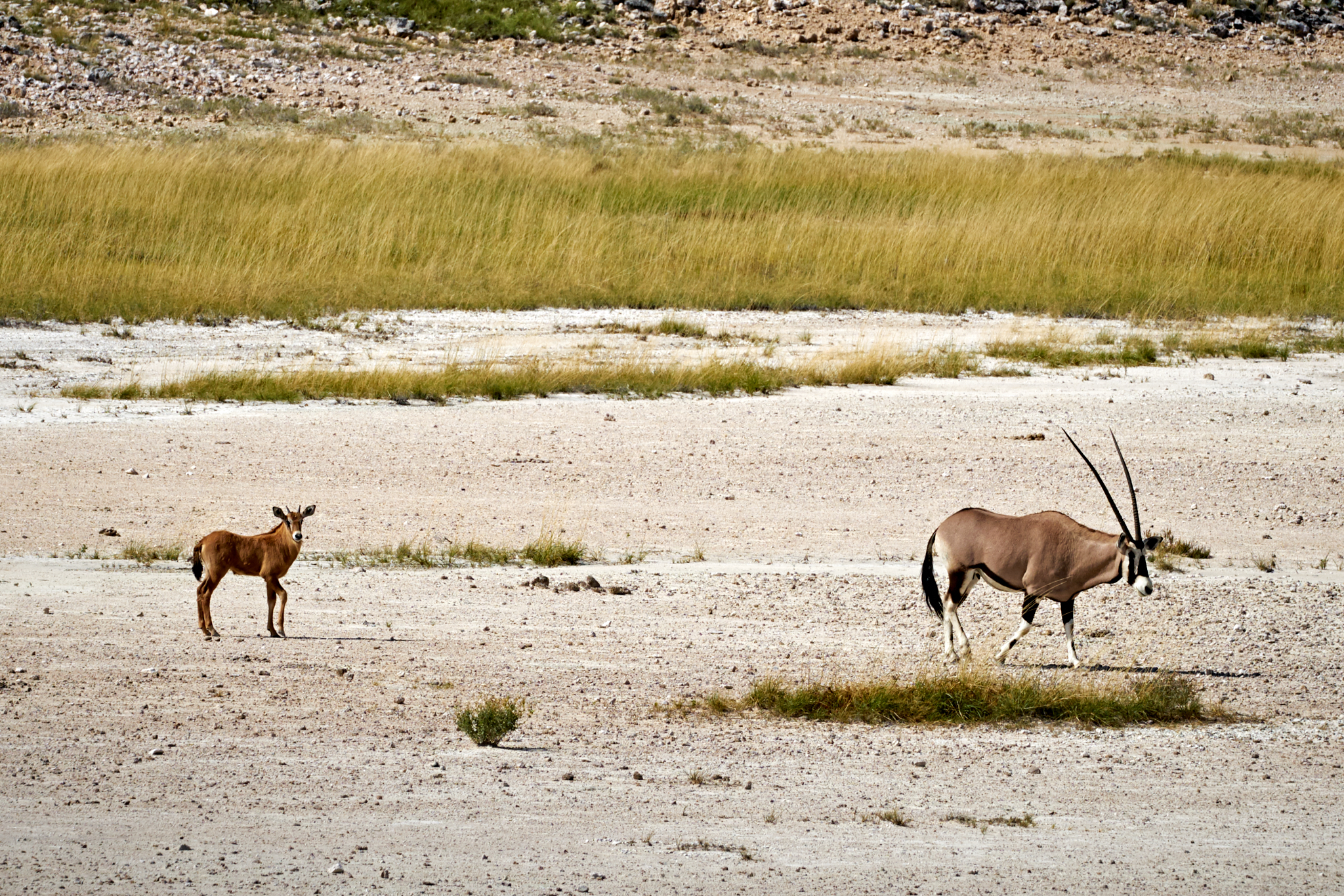
Oryx

Oryx
Eerie Skeletons and Towering Red Dunes of Deadvlei in Sossusvlei, Namibia
Deadvlei (Dead Marsh) is a white clay pan in the Sossusvlei area of the Namib desert, Namibia. Surrounded by the highest sand dunes in the world, Deadvlei was formed when the river Tsauchab flooded it’s banks and formed shallow pools. Camel thorn trees once grew in abundance here, but decades of drought and the advancement of the nearby dunes ultimately blocked the water source, and the trees in the vlei were unable to survive. The trees are believed to be up to 900 years old and have been dead since the 14th century. Scorched black by the intense sun and able to stave off decomposition due to the arid climate and lack of insects, these bizarre skeletons along with the white clay pan and surrounding red dunes together make for one of the most unique and beautiful landscapes on earth. Click on any image to view Hi-Res version.

- Epic view from the top of Big Daddy dune of the Deadvlei pan and surrounding landscape.
-

Entering the Deadvlei pan


Skeletal remains of long since dead camel thorn trees

Skeletal remains of long dead dead camel thorn trees

Some life stubbornly persists in the pan

Scorched black by the intense sun


Too dry to decompose

Barren forest amongst towering red dunes.
Climbing Big Daddy Dune, Namibia
Sossusvlei, with it’s massive red dunes and bleached salt pans, is Namibia’s most recognizable landscape. Big Daddy, the tallest dune in the Sossusvlei area and one of the highest dunes in the world, towers over the surrounding dunes at 325m (1,066ft). Extremely high heat and perpetually cloudless skies makes for an extraordinarily arduous 2 hour trek to the top, however climbers are rewarded with breathtaking views of the surrounding landscape. Click on any image to open Hi-Res copy.
 Extreme temperatures and long travel time to the dune mandates a very early predawn start to the trailhead. To grasp the scale of the dune, click on the above image to open a larger image, and look for the specks of people over our heads that have started up the ridge.


10 minutes down, almost 2 hours to go.

Windswept ridge.

Almost to the summit, but about to get sandblasted by heavy winds.

Epic views of the Deadvlei and surrounding landscape.


Sossusvlei Sandstorm

Sossusvlei, consisting of a salt and clay pan and surrounding massive red dunes, is located in the Namib Desert, and is the worlds oldest desert. It is where the dunes join together to prevent the Tsauchab River from flowing any further towards the Atlantic, however the river very rarely reaches this arid pan. Walking over the windswept Namibian pan at the beginning of our first climb to the dunes felt as if we were walking on Mars during a sandstorm.
Namibian 4 x 4

Namibia, Southern Africa – 2017
Spring of 2017 found my family heading off on an epic bucket-list journey through the wilds of Namibia in southern Africa. Traveling with Southern Cross Safaris, we planned to spend two weeks on backcountry safari, sleeping in tents and utilizing their custom-built “Unimog” off-road vehicle to penetrate deeper into the bush then normally travelled. What follows is a few (lots) of my favorite images from the trip, which were whittled down from the more than 3000 images I captured. Sit back, relax, and enjoy the show!
We start with a shot of a Namibian donkey cart, or Kalahari Ferrari, the quintessential Namibian 4×4 form of transportation seen throughout southern Africa. These fellas bid adieu to us as we left the paved roads a little over an hour into the trip, and for the better part of the next two weeks.


